IMD forecasts heavy rainfall in southern states
 IANS
Nov 8, 2021 11:22
0
IANS
Nov 8, 2021 11:22
0
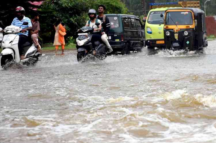
New Delhi, Nov 8 (IANS) A cyclonic circulation over Bay of Bengal that is likely to turn into a low pressure area and further turn into a Depression is set to bring in heavy spells of rain over the rain-battered Tamil Nadu, Puducherry, Coastal Andhra Pradesh and Kerala during next five days, India Meteorological Department (IMD) said on Monday.
Isolated heavy to very heavy rainfall is likely over Tamil Nadu on Tuesday and heavy to very heavy rain at few places with isolated extremely heavy rainfall are very likely on November 10 and 11.
Heavy to very heavy rain with extremely heavy rainfall at isolated places are also likely over south Coastal Andhra Pradesh during the same period.
"The cyclonic circulation over southeast Bay of Bengal and adjoining south Andaman Sea extends up to middle tropospheric levels. Under its influence, a low pressure area is very likely to form over southeast Bay of Bengal and neighbourhood during next 24 hours. It is likely to move west-northwestwards, concentrate into a Depression and reach near north Tamil Nadu coast by the early morning on Thursday," it said.
Under its influence, widespread light to moderate rainfall is very likely over Kerala, south Coastal Andhra Pradesh and Tamil Nadu during next five days.
Over the weekend, there was widespread, heavy to very heavy rainfall at a few places and extremely heavy rain at isolated places over north coastal Tamil Nadu and heavy to very heavy rainfall at isolated places over south coastal Andhra Pradesh with highest rainfall reported over Chennai City and suburban areas and Tiruvallur district Chennai (Nungambakkam - 227.0 mm, DGP Office - 227 mm, MGR Nagar - 171 mm, Anna City -164 mm and Tiruvallur - 205 mm.
Squally weather (speed reaching 40-50 kmph gusting to 60 kmph) over south-west & adjoining west-central Bay of Bengal and along and off south Andhra Pradesh-Tamil Nadu coasts and Gulf of Mannar during next four days, the IMD forecast said, adding, fishermen are advised not to venture into these areas.
Meanwhile, the Depression over east-central Arabian Sea moved west-northwestwards with a speed of 8 kmph lay centred at 8.30 a.m. of Monday about 840 kms west-southwest of Mumbai (Maharashtra) & 800 kms west-southwest of Panjim (Goa).
It is likely to move nearly westwards and weaken into a well-marked Low Pressure area by Tuesday morning. Here too, fishermen have been advised not to venture into these areas as there is likely to be squally weather (speed reaching 45-55 kmph gusting to 65 kmph) very likely over east-central and adjoining west-central Arabian Sea and speed reaching 40-50 kmph gusting to 60 kmph during next 24 hours.
Rainfall recorded during 24 hours from 8.30 a.m. on Sunday till 8.30 a.m. on Monday in these areas: Perambur (Dist Chennai) 140 mm, Cheyyur (Dist Chengalpattu), Maduranthagam (Dist Chengalpattu), Cholavaram (Dist Tiruvallur) 130 mm each, Thondaiyarpet (Dist Chennai) 100 mm, Ayyanavaram (Dist Chennai), Chennai Collectorate (Dist Chennai), Gummidipoondi (Dist Tiruvallur), Parangipettai (Dist Cuddalore), Pallipattu (Dist Tiruvallur), Ambathur (Dist Tiruvallur), Poonamallee (Dist Tiruvallur), Red Hills (Dist Tiruvallur) 90 mm each.
Tambaram (Dist Chengalpattu), Coimbatore South (Dist Coimbatore), Puducherry (Dist Puducherry), Alangayam (Dist Tirupattur), Uthukottai (Dist Tiruvallur), DGP Office (Dist Chennai), Chengam (Dist Tiruvannamalai), Marakkanam (Dist Villupuram) recorded 80 mm rainfall each and Chennai (N) (Dist Chennai), ACS College (Dist Chennai), Sriperumbudur (Dist Kancheepuram), MGR Nagar (Dist Chennai), Ponneri (Dist Tiruvallur), Thirukoilur ARG (Dist Kallakurichi), Anna University (Dist Chennai), Chengalpattu (Dist Chengalpattu), RCS Vallam (Dist Villupuram), Valavanur (Dist Villupuram) 70 mm each.